
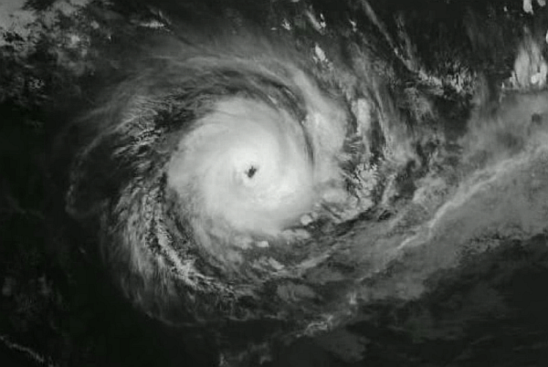
Tropical Cyclone Debbie formed in the Coral Sea on Saturday 25th March, 2017
Tropical Cyclone Debbie intensified to a severe category 3 cyclone mid morning Monday 27th March and has intensified to Category 4 on approach to the Central Queensland coast.: http://www.bom.gov.au/products/IDQ65002.shtml
Headline:
Debbie is currently a category 2 cyclone centred to the southwest of Collinsville.
Areas affected:
Warning zone: Ayr to St Lawrence, including Mackay, and the Whitsunday Islands, extending inland to Charters Towers, Mount Coolon, and Moranbah.
Details of Tropical Cyclone Debbie at 10:00 pm Tuesday, 28th March AEST:
Intensity: category 2, sustained winds near the centre of 100 kilometres per hour with wind gusts to 140 kilometres per hour.
Location: within 35 kilometres of 20.7 degrees South, 147.8 degrees East , 90 kilometres west southwest of Proserpine and 15 kilometres south southwest of Collinsville .
Movement: west southwest at 13 kilometres per hour .
Tropical cyclone Debbie is continuing to weaken as it moves slowly inland. It is currently a category 2 cyclone, and is expected to weaken further tonight. On Wednesday, the remnant tropical low will curve from the current southwesterly motion to a more southerly track over inland Queensland.
Although the peak winds near the centre are weakening rapidly tonight, heavy rainfall is expected to continue across the region for the next 12 to 24 hours, gradually contracting southwards with the system.
Hazards:
The DESTRUCTIVE CORE of tropical cyclone Debbie is located southwest Collinsville and is continuing to move inland. DESTRUCTIVE WINDS with gusts to 140 km/h are still possible near the cyclone centre.
GALES are occurring about the coast and islands between about Cape Upstart and St Lawrence, and extend inland to Proserpine, Collinsville, and Moranbah. These GALES are expected to extend inland further to locations such as Charters Towers and Mount Coolon tonight.
Abnormally high tides are expected between Bowen and St Lawrence. Large waves may produce minor flooding along the foreshore. People living in areas likely to be affected by this flooding should take measures to protect their property as much as possible and be prepared to help their neighbours.
Areas of heavy rain with the potential to cause severe flash flooding have developed around the Central Coast and Whitsundays district. These heavy rain areas are expected to spread further inland through central and southeastern Queensland. Widespread daily rainfall totals of 150 to 250 mm are expected, with significantly higher totals possible locally. This is likely to lead to major river flooding over a broad area this week, and a Flood Watch for coastal catchments between Ayr and the NSW border, extending inland to parts of the Central Highlands and Coalfields, Central West, Maranoa and Warrego, and Darling Downs and Granite Belt forecast districts.
A map showing the track of the cyclone is available at: http://www.bom.gov.au/cyclone
Australian Government Bureau of Meteorology
Queensland
Tropical Cyclone Warning Centre